Kitchen conversations.
Wife: “How does a 40-mile hike down the Rogue River sound to you?”
Me: “Sign me up.”
There was more to the conversation, but that was the gist of it. The trip we signed up for was a 40-mile hike down the Rogue River, where the river carves a canyon through the Siskiyou Mountains roughly between Grants Pass and its mouth at Gold Beach. The trip spanned 4-days, hiking from lodge to lodge with a daypack while our luggage was shuttled downriver via raft to meet us at the next lodge.
 At the start of a trip it’s all organized, neatly, and tightly packed, everything fitting together in its place. Not so much by the end of the trip.
But first, we had to drive south from our place just north of Seattle to the starting point at Grants Pass. That drive and points along the way is Day 1 for this diary. We took the long way, which I believe my wife had secretly planned without telling me. She’s the planner and she plans. I drive while she googles places to see and eat along the way.
We hit the road not too early, navigated through Seattle, Tacoma, Portland, and stopped for lunch in the small town of Coburg, Oregon. Coburg is on the National Register of Historic Places as the Coburg Historic District. It’s a small town worth another visit like several other historical small towns in the Willamette Valley. We had lunch there at Chief’s Brew House, located in the historic William Van Duyn house.
 The William Van Duyn House. Date Built: 1877. Check out the amazing dogwood on the right.
 Lunch at Chief’s Brew House, Coburg, OR
When we hit Roseburg, my wife threw out a suggestion that we exit Interstate 5 and take the Rogue-Umpqua Scenic Byway, which according to her added only an extra two hours of driving compared to a straight shot down Interstate 5. She’d been browsing the Oregon Scenic Byways guide that I’d ordered weeks ago. I’m sure this was part of her plan.
Our first stop along the scenic route was a place called Colliding Rivers, where the North Umpqua River and Little River merge head-on in a swirl of whitewater. It’s probably a little more exciting at higher water.
 Colliding Rivers. Glide, OR. North Umpqua River (right) and Little River (left) merge head-on.
It wasn’t too long after we left Colliding Rivers that we entered the Archie Creek Fire area that burned in the summer of 2020. Driving into a large burned area was unexpected. We had no idea. From my post-trip research I learned that the Archie Creek Fire had burned 131,542 acres. A total of 109 homes were lost.
 Aftermath of the Archie Creek Fire along Oregon Route 138
 Aftermath of the Archie Creek Fire along the North Umpqua River
Moving farther along Oregon Route 138, past the burned area, we stopped at Mott Bridge, constructed in 1935 and 1936 by the Civilian Conservation Corps. More on the bridge here: Mott Bridge. Worth the quick stop and restroom break.
 Mott Bridge, spanning the North Umpqua River. Constructed in 1935 and 1936 by the CCC. This is the best view I could get without scrambling down a steep bank through poison oak (nominated as the state plant of Oregon).
Next stop was Toketee Falls, one of several waterfalls along this highway. We could pick only one waterfall because we had more miles to go to get to Grants Pass. This waterfall was a good pick. We followed a 0.4 mile trail including 200 steps to get to the waterfall viewpoint.
 Toketee Falls. It’s a double, 40 foot drop on the upper and 80 feet on the lower. The cliff face is basalt. You can see the columnar jointing formed by the cooling and contraction of the lava flow as the lava cooled and solidified. The lava flow is about 25,000 years old and originated from Mt. Bailey, a volcano you’ll see later in this diary.
The trail to the falls, while short, went through old growth forest and next to the churning river. I photographed a few of the plants and wildflowers, mainly for iNaturalist posting, but the trillium turned out nice.
 Pacific Trillium (Trillium ovatum) at Toketee Falls.
PacificCorp operates several hydroelectric facilities along the North Umpqua River, including at Toketee. PacificCorp diverts some water around the falls through flumes and penstocks. Because of that diversion, the falls get a steady flow that doesn’t vary much, never seeing any peak flow, which would make the falls even more spectacular.
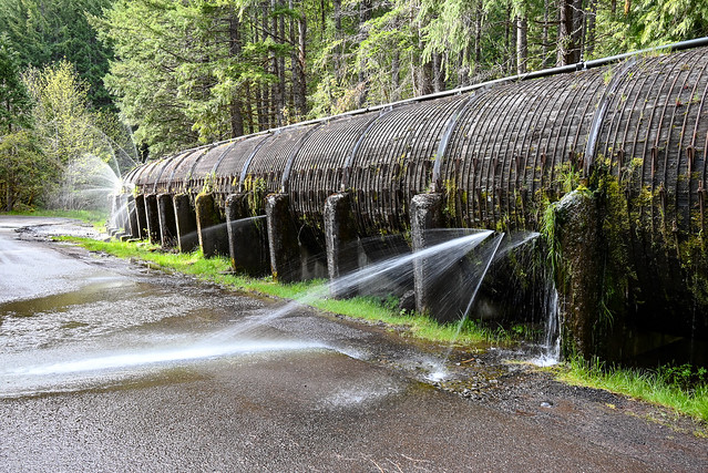 Leaking wood-stave penstock at the Toketee Falls trailhead
The highway climbed gradually farther up into the Oregon Cascades until we were at snow level. There we entered another burned over area. This one from the 2020 Thielsen Fire.
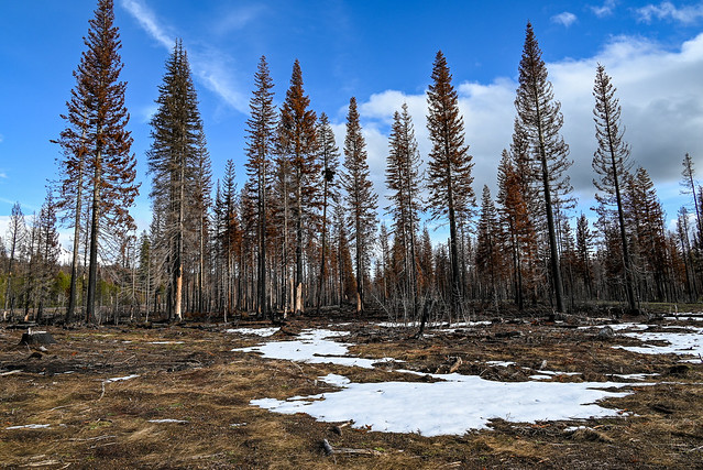 Thielsen Fire aftermath
 Thielsen Fire restoration work. Each cone protects a planted tree sapling.
Let’s do some volcanoes. The Cascade Range is essentially a chain of volcanoes extending from southern British Columbia to northern California, part of the whole Pacific ring of fire. I won’t go into detail on the plate tectonics. The overly simplified explanation is that volcanism in the Cascades is the result of a convergent plate boundary where an oceanic plate, the Juan de Fuca plate, dips under the North American plate like a huge diving conveyor belt, causing melting at depth, which bubbles up as magma. Where magma reaches the surface, a volcano forms. Other effects of this convergent plate boundary may be brought up on Day 2.
As we entered the snow zone, we were treated to spectacular views of a couple volcanoes you may never have heard of. When it comes to volcanoes, Oregon does not disappoint (e.g. Crater Lake).
 Mt. Bailey, an andesitic cone atop a shield of basaltic andesite, with slopes eroded by glaciers. Note the meadow area in the foreground is covered with a layer of wood chip mulch as part of the Thielsen Fire restoration.
 Mt. Thielsen, older than Mount Bailey, a basaltic cone active about 300,000 years ago. Glaciation has significantly eroded the volcano, exposing the central plug, the main magma conduit. Mt. Thielsen is known as the lightning rod of the Cascades because of the numerous lightning strikes it attracts.
We still had two or three more hours yet to get to Grants Pass. So, we made a straight shot of it, no more stops. We checked in and settled into the hotel around 9 pm when most restaurants were closing. But we found a Mexican restaurant a few blocks away that was still open.
 Late dinner at El Molcajete in Grants Pass. Who ate all the chips?
Thanks for hanging with me on Day 1, especially with landscapes and food. Upcoming on subsequent days:
Day 2 — Oregon Caves with some geology jibber jabber
Day 3 — Wildflower endemics in the Klamath/Siskiyous, and where we’re actually hiking down the Rogue River
Day 4 — ?
What is happening nature-wise and weather-wise in your part of the world? Show and share. We want to see. Please comment, converse, and raise questions.
Quote of the day: “I don't get distracted, I go on side quests”
|
THE DAILY BUCKET IS A NATURE REFUGE. WE AMICABLY DISCUSS ANIMALS, WEATHER, CLIMATE, SOIL, PLANTS, WATERS AND NOTE LIFE’S PATTERNS.
WE INVITE YOU TO NOTE WHAT YOU ARE SEEING AROUND YOU IN YOUR OWN PART OF THE WORLD, AND TO SHARE YOUR OBSERVATIONS IN THE COMMENTS BELOW.
|
Thanks for reading the Daily Bucket.
Phenology is how we take earth’s pulse.
We discuss what we see in each Bucket.
We value all observations, as we ponder life’s cycles.
Now it’s your turn.
Please comment about your own natural area, and include photos if possible. We love photos!
To have the Daily Bucket in your Activity Stream, visit Backyard Science’s profile page and click on Follow, and join to write a Bucket of your own observations.


